Vung Chua - Yen Island

Vung Chua - Yen Island

General Vo Nguyen Giap to rest in peace in the area of Vung Chua – Yen (swallow) Island in Quang Dong commune of Quang Trach district. This place has attracted the attention of millions of Viet Nam people, it is expected to be a new destination of local and foreign tourists on their Viet trans trip.

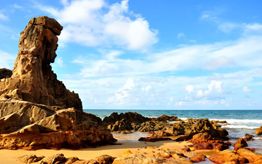
Vung Chua – Yen (swallow) Island located at the foot of the Hoanh Son range, about 10km from the poetic Ngang Pass to the southeast. From Tho Son peak looked toward the sea is the magnificent natural scenery, peaceful seawater clouds. Being surrounded by the three islands of Hon La, Hon Gio and Hon Nom (Swallow Island), Vung Chua area is pretty airtight, where is the shelter for many boats during storms.

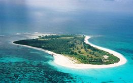
According to the older people in the village of Tho Son, Vung Chua name derived by peaceful water here like as "Vung", hundreds of years ago, there is a sacred pagoda which now remains the substructure due to devastation from time and wars . The original name of swallow island is Hon Nom, called “nom” downwind. Later people called Yen (swallow) island because It is the home to swallow birds come to make nests so the island is named after the bird . Cover an area of 10 hectares, the space here is extremely spacious. Amid the sea, the Swallow Island emerges as a green jewel, with poetic and wild beauty.

Vung Chua is one of the beautiful landscapes, lying adjacent to the Hon La deepwater bay which records of Cao Xuan Duc (in the Nguyen dynasty) in his book Dai Nam Du Dia Chi called the La Son bay. It is surrounded by mountains firmly, the landward side is the Hoanh Son range “ like as the shape of coiled dragon and getting down tiger” with Mui Rong peak  to the northwest and many small islands to the east.

From Tho Son peak looked toward the sea, the space is extremely spacious and peaceful that the reason general Vo Nguyen Giap chosen to rest in peace in the area of Vung Chua – Yen (swallow) Island. Mr. Luong Van Luyen, director of the department of Cultural, Sport and Tourism of Quang Binh said Vung Chua is a beautiful land, majestic mountains, gentle sea waves. With many potentials for development of tourism, in the future, Vung Chua - Yen Island will become an attractive destination linking with Ngang pass,  Lieu Hanh Princess temple… forming a attractive spiritual tourism route, not only the beautiful scenery but also very sacred.

Other articles

Phong Nha - Ke Bang National Park

Phong Nha - Ke Bang National Park

The World Natural Heritage Site of Phong Nha - Ke Bang National Park is situated in Quang Binh Province, 50km ...

World’s Largest Cave – Hang Son Doong Cave

World’s Largest Cave – Hang Son Doong Cave

It had lain undetected beneath the Annamite Mountains in a remote part of central Vietnam for millions of years until ...

Phong Nha Cave

Phong Nha Cave

Located in Phong Nha Ke Bang park, a UNESCO World Heritage Site, also recognized by British Cave Research Association as ...

Paradise cave

Paradise cave

Quang Binh province is famous for one thing. Every year, heaps upon heaps of travelers come here to see the ...

Van La Underground Tunnel

Van La Underground Tunnel

Van La Underground Tunnel belongs to Luong Ninh, a village which is only 7km to the South of Dong Hoi ...

Dong Hoi citadel

Dong Hoi citadel

Dong Hoi Citadel is located in Dong Hoi city, Quang Binh Province. It is a complex of high fences and ...

Long Dai ferry boat

Long Dai ferry boat

Situated on the strategic road No.15 (now the east branch of the Ho Chi Minh trail), Long Dai ferry-boat was ...

Tam Co cave

Tam Co cave

“Tam Co” cave (the Eight Voluntary Youths cave) is located at km16+500 on the Road No.20 which is part of ...

Bang mineral hot spring

Bang mineral hot spring

Bang Mineral Hot Spring is located 60km south of Dong Hoi City, in Kim Thuy Commune, Le Thuy District, Quang ...

Tien Son Grotto

Tien Son Grotto

Tien Son Grotto lies in Phong Nha - Ke Bang tourist complex that comprises natural beauty-spots in Quang Binh Province. ...

Tu Lan cave system

Tu Lan cave system

The Tu Lan Cave System is located at Tan Hoa village, Minh Hoa District, Quang Binh. It is about 70km ...

Sinh Ton Valley and Aquarium Palace cave

Sinh Ton Valley and Aquarium Palace cave

Tourist route discovery of Sinh Ton (Survival) Valley and Hang Thuy Cung (Aquarium palace cave) has a total length of ...

Rao Thuong spring

Rao Thuong spring

At Km 37 of the Ho Chi Minh Trail West, crossing the primeval forest and the winding Rao Thuong stream, ...

Bao Ninh peninsula

Bao Ninh peninsula

Bao Ninh peninsula features the sea to the east, the Nhat Le river to the west and the Nhat Le ...

Than Dinh mountain

Than Dinh mountain

Than Dinh Mountain (also known as Non Pagoda Mountain) is about 25 km away from Dong Hoi city in the ...

Chay River

Chay River

The 10km-long Chay River is an estuary of Son River with a gentle stream flow, pure water and many species ...

Nhat Le Beach

Nhat Le Beach

About 2 km to the northeast from Dong Hoi city is the beautiful Nhat Le beach with its endless white ...

Bird Island

Bird Island

Chim (Bird) island (or Gio (Wind) Island) is located in Quang Dong commune, Quang Trach district, the north of Quang ...

Mooc Spring Ecotrail

Mooc Spring Ecotrail

The Nuoc Mooc eco-trail is located next to the West branch of the Ho Chi Minh Trail. The word “Nuoc ...

Da Nhay beach

Da Nhay beach

Under the Ly Hoa Pass, where is borders between the sea and mountain have a rock ground with a lot ...

Bau Tro Lake

Bau Tro Lake

Bau Tro is a freshwater lake located between the sand dunes and Nhat Le beach. This lake is an important ...

In association with
Asta  Pata  Vista  vietnamtourism  footprint  Tripadvisor