The World Natural Heritage Site of Phong Nha - Ke Bang National Park is situated in Quang Binh Province, 50km northwest of Dong Hoi City and 500km south of Hanoi. The land of Phong Nha - Ke Bang covers an area of about 200,000ha in Quang Ninh, Bo Trach, Tuyen Hoa and Minh Hoa districts of Quang Binh Province and contains part of the oldest karst area in Asia which was formed 400 million years ago during the main periods of the Earth. The karst plateau stretches from Phong Nha - Ke Bang of Vietnam to Khammouane Province of Laos, covering an area of 400,000ha, making one of the largest karst areas in the world with global out-standing values of geomorphology and geology.
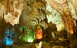
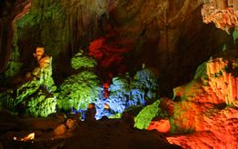
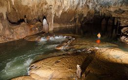
Phong Nha - Ke Bang is considering as kingdom of grottoes and caves. There exists a system of hundreds of imposing grottoes and caves, with the total length of nearly 100km (excluding undiscovered ones).
Located within the land of Phong Nha - Ke Bang, the national park established in December 2001 consists of the 85,754ha core zone and the 195,400ha buffer zone. Karst formation, hundreds of grottoes and caves, subterranean rivers, rare flora and fauna system listed in Vietnam.
Quang Binh Province
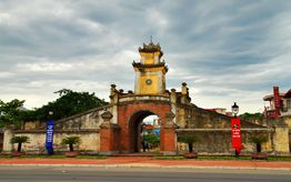
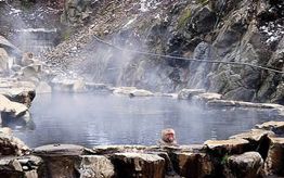
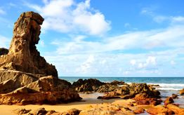
Located in .the North-Central region of Vietnam, Quang Binh Province has an area of 8,055km2. The nature has endowed this province with magnificent landscapes, including Ngang Pass (situated between Ha Tinh and Quang Binh provinces), Ly Hoa Pass, Nhat Le and Da Nhay beaches, and Bang Hot Spring. In addition, Quang Binh is also famous for its well-preserved architectural constructions of great cultural and historical values. Among them are Quang Binh Gate, Dong Hoi Citadel, and many historical war retics of the anti-US aggression.
Climate
The climate in Phong Nha - Ke Bang is tropically hot and humid. The annual average temperature is 23 to 25°C, with a maximum of 41°C in the summer and a minimum of 6°C in the winter. The hottest months in this region fall from June to August, with an average temperature of 28°C, and the coldest months from December to February with an average temperature of 18°C. Annual rainfall is 2,000mm to 2,500mm, and 88% of the rainfall is from July to December. Flood in the valley area occurs from September to November, but in dry season from February to August, the streams are almost dried up. Relative humidity is 84%.
Nam's Red Book and World Red Book are highlights of the park.
Phong Nha - Ke Bang National Park contains an impressive amount of evidences of earth's history. It is a site of great importance for increasing our understanding of the geologic, geomorphic and geo- chronological history of the region. It was recognized as a World Natural Heritage Site at the UNESCO's 27th General Assembly session held in Paris in July 2003.
The natural beauty of Phong Nha - Ke Bang with spectacular caves and grottoes system, rich biological diversity and unique cultural characteristics of local community have been the most attractive to visitors from everywhere.
History of Exploration
Ancient Champa inscriptions carved on the cave wall proved that the Phong Nha Cave was discovery by Cham people long ago.
In 1550, Duong Van An (1514 - 1591), a mandarin in Mac Dynasty, was the first Vietnamese man to write about Phong Nha Cave.
In 1824, the cave was conferred the title "Dieu ung chi than" by King Minh Mang. This cave was even depicted in one of the Nine Urns (Cuu Dinh) in the Hue Citadel. In the late 19th century, Leopold Michel Cadière, a French Roman Catholic priest, conducted an expedition to explore Phong Nha Cave, where he discovered Champa inscriptions. He proclaimed Phong Nha Cave "The number one cave of Indochina". In July 1924, Barton, an English expeditionist, ranked Phong Nha Cave with famous caves in the world as Padirac (France), Cuevas del Orach (Spain) in terms of its magnificent beauty.
In 1935,a local inhabitant accidentally dis-covered a dry cave, 1,000m from the mouth of Phong Nha Cave, at an elevation of 200m. It was called Tien Son Grotto.
In 1937, the Bureau of Tourism of French Resident Superior (in Hue) issued a brochure to introduce tourism in Quang Binh. Phong Nha Cave was included in this introduction and ranked second in the Indochina peninsula.
Prior to 1990, several explorations were conducted by Vietnamese and foreign scientists but the mystery of this area still remained.
In 1990, for the first time, Hanoi University and the British Caving Association coordinated to explore caves and grottoes in the area comprehensively. Research of Vom Cave was completed at that time.
In 1992, in the second exploration, a group of 12 British scientists, 6 professors from Hanoi University discovered 7,729m of Phong Nha Cave and 13,690m of Vom Cave and adjacent caves and grottoes.
In 1994, 11 British scientists and 5 Viet-namese professors of Hanoi National University conducted the third explo-ration researching 20 caves with total length of 70km, of which 17 caves in Phong Nha and 3 ones in Ke Bang.
In 1999, scientists from the Vietnam - Russia Tropical Centre also surveyed the fauna and flora system in the area of Ke Bang.
In 2005, a dry cave named Thien Duong Cave was discovered.
In the period of 2007 - 2008, the British Caving Association organized a survey in upstream part of Chay River, Vom Cave and some new caves in Thuong Hoa, Hoa
Son, Dan Hoa, Trong Hoa (Minh Hoa Dis-trict), Truong Son (Quang Ninh District). They also re-mapped system of Phong Nha caves and grottoes.
In April 2009, a survey by the British Caving Association and Hanoi National University revealed some remarkable outcomes: 20 new caves with total length of 56km; discovery of over 5km Cha Lo Cave (Minh Hoa), 57km Phong Nha Cave (45km previously), 35km-Vom Cave; Khe Ry Cave possessing the world's longest subterranean river; Son Doong Cave being the world's largest cave; a karst sinkhole in Vom Cave with the depth of over 255m.
In 2012, 41 new caves were found in the core zone of Phong Nha - Ke Bang with total length of 20km. Noticeably, there exists a 50m high and 4km long grotto named Ky Grotto at the bottom of a 320m deep sinkhole.
Geological Value
The karst mountains area in Phong Nha - Ke Bang can be compared with a huge geological museum providing a lot of valuable information about the earth's prolonged geological process through various periods about 400 million years ago.
The geological structure here expresses the diversity and long development his-tory of the earth's crust. The earth's crust has undergone several main develop-ment stages (from the Ordovician period up to now) with 5 tectonic megacycles corresponding with the 5 geological evolution stages of the world.
Late Ordovician - Early Silurian stage (463.9 - 430 million years): The earth's crust was broken down and then sub-sided, forming the terrigenous sediments of the Long Dai formation, yielding fossils of Graptolithina.
Middle - Late Devonian stage (386 - 362.5 million years): The earth's crust subsided for the second time, and the sea expanded. The sediments that evolved were composite of sandstone, siltstone and clay stone intercalated with limestone; corresponding to Rao Chan, Ban Giang, Muc Bai, Dong Tho, Cat Bang and Phong Nha.
Carboniferous - Permian stage (362.5 - 245 million years): This was the stage when the Carboniferous - Permian lime-stone massifs were formed.
The earth's crust in the Phong Nha - Ke Bang area was broken down for the third time, creating shallow, isometric basins (marginal sea of continent), and yielding fossils aged from the Lower Carboniferous to the Middle Carboniferous and finally the Permian. Specific characteristics were La Khe, Bac Son, Khe Giua formations.
Mesozoic orogenic stage (Triassic, Jurassic, and Cretaceous): The Phong Nha - Ke Bang limestone massif was lifted up above the sea level, and karst, weathering and denudation processes occurred. Mu Gia formation is typical with Chan Riu fossils.
Cenozoic stage: This was the stage when the mountains and old karst cave systems of Phong Nha - Ke Bang were formed, with typical of Dong Hoi formation.
The vivid evidences of the earth's history are useful in researching the history of geology and topography of the area.
Geomorphologic Value
The endogenous and exogenous geological processes, which have occurred from Triassic up to now, have created the diverse topography and geomorphology of the area, with ages respective to the following surface levels:
1,600 - 1,400m level: corresponding with the first generation of caves dating from the Oligocene.,
1,000 - 800m (in the west) and 700 - 600m (in the east) level: corresponding with the first generation of caves dating from the Miocene (23 to 5 million years).
600 - 400m and 300 - 200m levels: corresponding with Pliocene (5 - 1.75 million years).
100 - 0m level: corresponding with various interglacial cycles in Quaternary (1.75 million years to present).
In general, there are two typical types of landforms in the Phong Nha - Ke Bang area namely non-karst and karst land-forms.
The karst landform occupies the majority of the area, with two groups. The karst on the surface includes cone and tower karst, karrens, valleys and dolines, border poije, etc. The subterranean karsts consist of caves along the valleys of Son and Chay Rivers and at the margins of the central limestone massif.
Non-karst landform includes three types: the middle and low round-top mountains developed in intrusive magmatic massifs; the middle denudation-structural mountain belts developed in terrigenous rocks of Cretaceous Age; and the low block-denudational mountain belts developed in other terrigenous rocks.
Natural Beauty
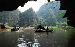
Phong Nha - Ke Bang is distinct from other tourist attractions in Viet Nam. It serves as a natural museum with evidences of the earth's crust formation. In addition, the Phong Nha - Ke Bang Natural Park still hides various myths of na-ture. It also has spectacular karst caves formed for hundreds of millions of years. In the area of Phong Nha - Ke Bang, one can also discover the peaceful scenes with simple house roofs, small boats, and ingenuous peasants who embody the fine cultural qualities of the Vietnamese peoples - industriousness, diligence and hospitality. Pure rivers and streams winding along Rocky Mountains and hide through grottoes and luxuriant trees with colorful flowers lying by river banks make a marvelous view for nature lovers. Phong Nha - Ke Bang boasts imposing limestone mountains in pyramid shapes with average height of about 800m such as Phu Sing Peak (965m), Ma Ma Peak (835m). Some peaks higher than 1,000m can be named as Co Rilata Peak (1,128m), Co Preu Peak (1,213m), and Phu Et Va Peak (1,512m) - the highest one.
Value of Biological Diversity
With its characteristics of topography, climate, soil and hydrograph, Phong Nha - Ke Bang is endowed with a rich, diversified and unique flora system. Investigations show that Phong Nha - Ke Bang has a large tropical forest floor. It covers 96.2 percent of the natural area, of which nearly 90 percent is covered by primeval forests. The diversity of rare and precious species of animals and plants in Phong Nha - Ke Bang is corollary of its natural conditions, and is a feature of the forest ecosystem.
Surveys show that the flora system of Phong Nha - Ke Bang belongs to 193 families, 906 genera, and 2,651 vascular plant species including 62 listed in Viet Nam's Red Book, 79 in the IUCN's Red List of Threatened Species 2006 and 419 endemic species.
The favorable conditions in Phong Nha - Ke Bang are also a good environment and a safe habitat for various species of animals. According to statistics, this area preserves 132 species of animals, 46 of which are listed in Vietnam's Red Book and 34 in the UCN's Red List. Three rare and precious species - Sao la, Mang Lon and Mang Truong Son - have been dis-covered in this area, beside other rare species like gayals, tigers...
Of the 96 recorded reptile and 45 amphibian species, 22 are listed in Viet Nam's Red Book and 18 in the UCN's Red List.
In addition, there are 270 butterfly species, 124 fish species; 338 bird species including 20 species listed in Vietnam's Red Book and 17 in the lUCN's Red List. Particularly, black-comb blue pheasants (ga loi lam mau den), white-tail blue pheasants (ga loi lam duoi trang) and peacocks are the global-level endangered species.
Archeological, Cultural and Historical Values
Phong Nha Cave contains vestiges of the Cham ethnic group (altars and inscriptions on the cliffs) and of the ancient Vietnamese people (statues of Buddha, worshipping tablets, ceramics). The cave used to be the resistance base of King Ham Nghi in the fight against French in the late 19th century.
The area of Phong Nha - Ke Bang also has numerous historical sites related to the anti-US Resistance War, such as Xuan Son Ferry, Thanh Nien Xung Phong (Vanguard Youth) Cave, Road No. 20 and the Ho Chi Minh Trail, which suffered severe bom-bardment during the war. It is in these places where Quang Binh people and soldiers showed their iron will and made numerous glorious feats of arms.
Inhabitants in this area include the ethnic minorities of Sach, May, Rue, Arem and Ma Lieng. Their life and customs con-tribute to increasing the diversity of tourist products in this world heritage site.
By exploring the beautiful landscape and Phong Nha - Ke Bang National Park, visi-tors will have opportunities to study the cultural beauty of these communities.

