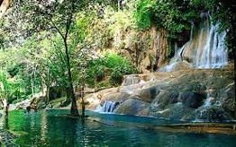
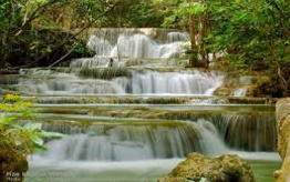
A conserved park covering an area of approximately 1,20 square kilometers, featuring lush tropical forest, mountainous landscape, headwater sources and rare wildlife animals. Visitors shouldn’t miss to visit two main view points: Doi Tong Palae which is about 300 metres uphill from where NamtokChokkadin is visible, and NoenKutDoi, that national park’s highest peak offering a panoramic view of the mountains, Vajiralongkorn Dam and Khao Chang Phueak. For adventurous travelers, trekking to one of three major waterfalls: NamtokChokkadin, NamtokPhaPae and Namtok ChetMit can be a thrilling experience. A four-wheel drive car and hired guide will be needed. Accommodation and camping ground is available.
How to get there :
By Car
To get there, from Kanchanaburi, follow Highway 323 to Amphoe Thong Pha Phum and turn into Highway 3272 (Thong Pha Phum – Pilok Mine) for some 57 km. to Thong Pha Phum National Park’s headquarters. The road, though asphalted, climbs up the mountain with several sharp curves; drivers will have to drive carefully.